
Looking for an east coast mini thru-hike you can knock out in less than a week? One that passes through lush forests, rocky overlooks, historic landscapes, with fascinating rock features, miles of beautiful green tunnels, spectacular, if not occasional views and a shelter system that will spoil you for all other hikes?
Ladies and gentleman, look no further than the Laurel Highlands Hiking Trail.
For years, I drove beneath the Laurel Highlands Hiking Trail bridge spanning Interstate 70 every time we visited my in-laws in western Pennsylvania and thought, “huh, I wonder what’s up there?”
After finally thru-hiking all 70 miles of the trail over six days, I can confidently say the Laurel Highlands Hiking Trail is one of the most underrated backpacking trails in the eastern United States.
Whether you’re planning your first backpacking trip, looking for a PTO-friendly thru-hike, or a shakedown hike before a bigger adventure like the AT or PCT, this complete guide covers everything you need to know about hiking the Laurel Highlands Hiking Trail.

Disclosure: This page may contain sponsored content or affiliate links, including Amazon links, where I earn a small commission from any purchase – at no extra cost to you. This commission helps keep Brooke In Boots up and running. As always, all opinions are 100% honest and my own!
About the LHHT: The Laurel Highlands Hiking Trail
Laurel Highlands Hiking Trail At a Glance
📍 Location: Southwestern Pennsylvania
🥾 Distance: 70 miles
↔️ Trail Type: Point-to-point
⛰️ Difficulty: Moderate to Difficult
📈 Elevation Gain: ~12,000 feet
📅 How Long It Takes: Usually 4–7 days
🏕️ Camping: Designated Shelter Areas Only (Tent Sites Also available)
🎟️ Permits/Reservations: Required for overnight stays in shelter areas
🐕 Dogs Allowed: Yes
🚰 Water Availability: Seasonal; very limited in some sections (miles 50-70)
📶 Cell Service: Intermittent; available at most shelter areas except Ohiopyle
🍂 Best Time to Hike: May–October
➡️ Recommended Direction: North to South (SoBo) / Seward to Ohiopyle

The LHHT: What Is It?
The Laurel Highlands Hiking Trail (often abbreviated as the LHHT) is a 70-mile point-to-point backpacking trail that follows the ridgeline of Laurel Ridge through southwestern Pennsylvania.
The trail stretches from the small town of Seward in the north to Ohiopyle State Park in the south, traversing the length of Laurel Ridge State Park while passing through a mix of public lands, including nearby State Forest and State Game Lands.
The trail itself exists because of a remarkable conservation effort. Throughout much of the late 1800s and early 1900s, the forests of the Laurel Highlands were heavily logged and exploited for natural resources. By the mid-20th century, much of the ridgeline had been stripped of the old-growth forests that once covered these mountains. The creation of Laurel Ridge State Park and the construction of the hiking trail helped protect and restore the landscape, transforming it into the lush green corridor hikers enjoy today.

Why Hike the Laurel Highlands Hiking Trail?
Before hiking the Laurel Highlands Hiking Trail, I wasn’t entirely sure what to expect. As someone who has spent most of her backpacking career hiking out west, I wondered how a week spent hiking through Pennsylvania’s forests would compare.
Thankfully, the LHHT surprised me in all the best ways.
Over the course of 70 miles, the trail winds through lush forests, tunnels of mountain laurel and rhododendrons, moss-covered rock formations, scenic overlooks, and some of the most beautiful stretches of woodland hiking I’ve experienced anywhere in the country.
One of the things I loved most about the trail was how remote it felt. Despite hiking during late-spring, (May) I often went hours, at one point even 2 full days, without seeing another person. In an era when many popular backpacking trails can feel crowded, that kind of solitude feels wildly rare on the East Coast.
The Laurel Highlands Hiking Trail is also an excellent beginner-friendly thru-hike. Most hikers can complete the trail in 4-7 days, meaning you don’t have to blow all your precious PTO (or quit your job) to do it.
While the rocky terrain and frequent elevation changes will certainly test your endurance strength, the trail’s relatively short length, straightforward logistics, and excellent shelter system make it an approachable challenge for newer backpackers and experienced hikers alike.
Whether you’re looking for your first multi-day backpacking trip, a shakedown hike before tackling a longer trail like the Appalachian Trail or Pacific Crest Trail, or simply a memorable week in the woods, the Laurel Highlands Hiking Trail delivers far more adventure than its modest 70-mile length might suggest.
Need help packing for your backpacking trip? Get my favorite backpacking gear suggestions that I use and love on the trail, delivered right to your inbox! Plus a backpacking checklist so you always pack exactly what you need!


Laurel Highlands Hiking Trail Map & Route Overview
Before heading out on trail, you’re going to want to download the official Laurel Highlands Hiking Trail map and carrying an offline navigation app like AllTrails.

The trail is exceptionally well-marked, but having access to water source information, shelter locations, and road crossings makes planning your daily mileage much easier.
I used both maps downloaded to my phone, and created a custom route with my shelters and important water sources marked on an AllTrails, which you can do using their new “Peak” subscription plan.

Need a map? Don’t forget to download your map and save it to your phone or GPS device before your hike! Get AllTrails Plus or AllTrails Peak (the most used trail app on my phone!) to download all your trail maps for offline use. Use my promo code brookeinboots30 to get 30% off your annual AllTrails subscription!
Laurel Highlands Hiking Trail Route Overview
The Laurel Highlands Hiking Trail stretches approximately 70 miles along Laurel Ridge in southwestern Pennsylvania.
The northern terminus is located near the town of Seward, while the southern terminus sits inside Ohiopyle State Park, one of Pennsylvania’s most popular outdoor recreation destinations. The trail is officially marked with mile-markers every mile, starting at Mile 0 in Ohiopyle, and ending at Mile 70 near Seward.
Along the way, the trail crosses several roads that provide access points, parking areas, and opportunities for emergency exits if needed. Most overnight hikers will spend their nights in one of the trail’s designated Shelter Areas, which are spaced roughly 6 to 12 miles apart along the route.
Water availability varies significantly depending on the season. During my hike, I found the northern section of the trail surprisingly dry despite the constant rainfall, while water sources became more frequent farther south.
The trail does not pass directly through any towns, so most hikers complete the route with a single food carry. However, there is one notable resupply opportunity at Highlands Market, located a short road walk off the trail near Seven Springs. I stopped here for a hot breakfast sandwich and met my husband for a resupply, and it makes a convenient option for hikers looking to break up the trail into two shorter food carries.

Northbound or Southbound?
While the Laurel Highlands Hiking Trail can be hiked in either direction, I strongly recommend hiking north to south (SoBo), beginning in Seward and finishing in Ohiopyle.
While the trail constantly climbs and descends regardless of direction, the initial climb out of Ohiopyle is STEEP, gaining about 1500′ in about 3 miles, as opposed to about the same in 5 miles starting out in Seward.
More importantly, the southern end of the trail is much more scenic and you get to end in the very cute outdoorsy town of Ohiopyle where you should do as I did and head directly to the Falls City Pub & Restaurant for a post-hike burger and brew.

How Difficult Is the Laurel Highlands Hiking Trail?
If you’re reading this and wondering, “ok, but how hard is this trail, Brooke?” The answer is: hard enough to challenge you, easy enough that if you’re already comfortable backpacking 10 miles per day, you can totally do it.
Don’t Let the Mileage Fool You
At “just” 70 miles long, it can be tempting to assume the Laurel Highlands Hiking Trail is an easy backpacking trip. I wouldn’t go that far.
The trail isn’t particularly high altitude, nor does it feature any massive mountain climbs. What makes the LHHT challenging is the constant accumulation of smaller obstacles. Expect rocky tread, root-filled trail, frequent steep climbs and descents, and plenty of mud and wet conditions, especially in the spring and early summer.
Elevation Gain and Loss
While the highest point on the trail is only about 2,950 feet above sea level, don’t let that fool you either.
Over the course of 70 miles, hikers will gain and lose roughly 12,000 feet of elevation. Rather than one big climb, the LHHT delivers a relentless series of smaller ups and downs that can feel surprisingly taxing by the end of the day.
The last 20 miles, (Mile 20-0) are particularly steep descents, and I ended up tweaking my knee at some point in this section, so make sure your body and training plan before this hike is prepared for those kinds of conditions.

Who Is This Trail Best For?
The Laurel Highlands Hiking Trail is a great pick for fit beginner backpackers looking for their first multi-day trip, intermediate hikers ready for a bigger challenge, and experienced backpackers seeking a long weekend adventure.
It’s also an excellent shakedown hike for aspiring thru-hikers preparing for longer trails like the Appalachian Trail or Pacific Crest Trail. The mileage, shelter system, and relatively straightforward logistics allow you to test your gear, trail routines, and backpacking skills without committing to a months-long trek.

Best Time to Hike the Laurel Highlands Hiking Trail
The Laurel Highlands Hiking Trail can be hiked year-round, but for most backpackers, the best time to visit is between May and October.
Spring (April-May)
Spring brings blooming wildflowers, rushing streams, and cooler temperatures that are ideal for hiking. It’s also one of the greenest times of year on the trail.
The tradeoff? Rain. Lots of it. So. Much. Rain.
During my hike in spring, I would guesstimate that it rained about half I was on trail. And when it wasn’t raining, my feet were still getting s oaked from the dewey, wet, grass and mud.
Summer (June-August)
Summer offers long daylight hours and lush green forests, making it a popular time for thru-hiking the trail. Expect warm to hot temperatures, high humidity, and plenty of bugs, including ticks, particularly after periods of rain.
Fall (September-October)
Cooler temperatures and spectacular fall foliage make this one of the most beautiful times to hike the LHHT. Just be aware that water sources may be fully dry, and even those marked on the official LHHT map may be unreliable. I would advise checking the comments on AllTrails for the most recent water source updates.
Winter (November-March)
Winter hiking on the LHHT is possible, but snow, ice, and freezing temperatures can significantly increase the difficulty of the trail. Thankfully, the park stocks wood at all the shelter areas during this season. Be prepared for winter travel conditions and check with the park regarding shelter availability and current trail conditions before heading out.

Laurel Highlands Hiking Trail Permits, Reservations & Fees
One of the biggest differences between the Laurel Highlands Hiking Trail and many other backpacking trails is that you cannot simply show up and camp wherever you’d like.
Overnight hikers are required to stay in designated Shelter Areas and make reservations in advance on the PA State Parks systems page, here.
At the time of writing, overnight permits cost approximately $4 per person per night for Pennsylvania residents and $5 per person per night for non-residents.
If you’re planning a thru-hike, I recommend booking your Shelter Areas as early as possible, especially if you’re hiking on weekends. The trail isn’t nearly as crowded as the Appalachian Trail, but popular shelters can and do fill up. Reservations are open 11 months in advance.

The Laurel Highlands Shelter Areas
If there’s one thing that sets the Laurel Highlands Hiking Trail apart from almost every other backpacking trail I’ve hiked, it’s the shelter system.
Every designated Shelter Area includes 5 “Adirondack-style” shelters (still no idea what that means, but hey, that’s what the LHHT calls them), designated tent sites, picnic tables, pit toilets, bear hang poles, trash disposal, and fire rings. Many shelter areas also include non-potable water pumps or nearby water sources.
The fireplaces in the shelters really sold it for me. After a long day of hiking through rain, mud, and rocky terrain, there is something deeply comforting about building a fire, hanging up wet clothes to dry, and settling into a shelter instead of pitching a tent.
In fact, I genuinely think these shelters may have ruined me for future backpacking trips.

Shelter Area Breakdown
The Laurel Highlands Hiking Trail has eight designated Shelter Areas spaced roughly every 6 to 12 miles along the trail. Here’s a quick breakdown of each shelter area, and what you can expect at them.
*are shelters I personally stayed at on my thru-hike.
Rte 56 Shelter Area (Mile 64.9)*
The northernmost shelter area at mile 5.1 from the northern terminus. This shelter area is a good spot to pick if, like me, you’re getting a late start on trail and driving in from out of the area, or hiring a shuttle to drop you off at the start. A real bonus for this shelter is that there is a flowing creek through the campsite, meaning you can filter water right at camp. The bad news is that the connector trail to access the shelter is about .25 miles off trail and STEEP, meaning you’re climbing right off the bat to start your day 2.
Rte 271 Shelter Area (Mile 56.9)
Located near Route 271, this shelter area is a good one to aim for if you can get an early start on day 1 and hike the 13.1 miles from the northern terminus. Natural water sources between here and the terminus are unreliable, so bring enough water for your entire day.
Rte 30 Shelter Area (Mile 46.5)*
My second favorite shelter area of the entire trail, this ridge-top shelter area arrived not a moment too soon at the end of a 19-mile day coming from the Rte 56 Shelter. Situated up on the ridge, a number of the shelters (#4, #5) here have fantastic views of the hills and valleys below.
Turnpike Shelter Area (Mile 38.2)
Located between two notable highlights of the LHHT: Beam Rocks and the bridge over Interstate 70. This shelter area is one of the few that also has a naturally occurring water source.
Rte 31 Shelter Area (Mile 32.5)*
This shelter area is located at just about the halfway point of the LHHT, and I personally loved that this is the shelter area that is closest to being directly ON the trail (the connector trail is only a few hundred yards at most). Just a heads up that if you are hiking solo or otherwise prefer more privacy, Shelters #4 and #3 face directly onto the path through camp, so basically everyone can see into your shelter when walking through. Shelter #5 offers slightly more privacy, but is up a steep hill, and #1 and #2 are directly next to each other, but a bit far from the wood-pile. So, pick your poison.
Grindle Ridge Shelter Area (Mile 24)
Located a few miles past the high point on the trail at Seven Springs Ski Resort. Note that the last natural water source before this shelter area, “Blue Hole Creek” at mile 24.5 is highly contaminated with lead and should NOT be used (there are signs everywhere but you’ll need to plan ahead beforehand).
Rte 653 Shelter Area (Mile 18.5)*
This is a popular shelter area for both thru-hikers and backpackers looking for a nice 1-2 night section hike of the LHHT. The Rte 653 parking area is located a short distance from a trailhead parking area, making this a good spot for a quick overnight, or a place to park your car for a 2-night section hike to Ohiopyle.
Ohiopyle Shelter Area (Mile 6.3)*
Located near the southern terminus in Ohiopyle State Park this is by far the most popular of the shelter areas thanks to it’s prime location near the State Park, and it’s natural beauty in a steep little valley (which, of course, you’ll have to hike down into and back up the next morning). This is also the only shelter area where I didn’t have Verizon cell service. Enjoy the opportunity to unplug! There is also a reliable creek running along the bottom of the shelter area before your final descent (and ascent, then descent again) into Ohiopyle.

Water Sources on the Laurel Highlands Trail
Water availability on the LHHT varies significantly depending on recent rainfall, the season, and which section of trail you’re hiking. Generally speaking, the northern sections of the trail tend to be drier, while water becomes more abundant as you move south toward Ohiopyle, after about mile 45.
Water spigots at the Shelter Areas are NOT POTABLE and don’t taste great. I used all natural sources along my hike. Either way, you’re going to need to bring a reliable water filter. I carried my trusty Sawyer Squeeze, CNOC thru-bottles and Smartwater Bottles, and a 2L CNOC Vecto Bag.
Many shelter areas have water available nearby, but I would never assume that every source shown on a map will be flowing when you arrive. Seasonal springs can dry up, particularly during hot summer weather, fall, or periods of drought.
Also, note, that the water at mile 24.5 Blue Hole Creek is CONTAMINATED with lead and should NOT be used (there are signs everywhere but you’ll need to plan ahead beforehand).

My advice? Carry a little more water than you think you’ll need, especially on the northern half of the trail, and always check recent trail reports on places like AllTrails before your trip.
Food Storage on the LHHT
Food storage has apparently been a real issue on the Laurel Highlands Hiking Trail in years past. Black bears are frequent in the area and can be aggressive when habituated to food when it’s not stored properly.
Many hikers I spoke with reported having mice and other rodents in the shelters. Personally, I heard (but did not see) mice on nights 1 and 2, but no time after that, and never saw any droppings.

That’s probably thanks to the new bear hang poles now installed at every shelter area! At the end of the day, ensure that all your trash is deposited in the bear-proof trashcans, and all your food and scented items are hung on the bear pole, usually located near the restrooms. No rope or bear hang equipment is necessary, you can use the attached pole to hang your food here, just keep it in a waterproof dry bag in case of rain.
Laurel Highlands Hiking Trail Shuttle & Parking Logistics
One of the biggest advantages of the Laurel Highlands Hiking Trail is that the logistics are refreshingly straightforward compared to many longer thru-hikes.
Most hikers choose to hike the trail southbound (Seward to Ohiopyle). To make that happen, you’ll either need 2 cars, a shuttle, or a willing friend or family member to drop you off.
For my hike, I parked at the southern terminus in Ohiopyle and used a shuttle from Wilderness Voyageurs to reach the northern trailhead in Seward. The ride took about an hour and allowed me to simply walk back to my car at the end of the trip.
Trailhead Parking Areas
There are several designated parking areas along the trail, making it easy to section hike or customize your itinerary.
| Location | LHHT Mile Marker |
|---|---|
| Seward Trailhead (PA Route 56) | Mile 70 |
| PA Route 271 Trailhead | Mile 56.9 |
| U.S. Route 30 Trailhead | Mile 45.8 |
| PA Route 31 Trailhead | Mile 30.6 |
| PA Route 653 Trailhead | Mile 18.8 |
| Jersey Hollow Parking Area | Mile 11.5 |
| Ohiopyle Trailhead | Mile 0 |
Shuttle Services
If you’re thru-hiking the entire trail, hiring a shuttle is by far the easiest option. Wilderness Voyageurs, based in Ohiopyle, offers shuttle services for LHHT hikers and is one of the most commonly used providers.
Want to see more of my hike? Check out my 2-part LHHT Hiking Vlog on Youtube, here!
Steal My 6-Day Laurel Highlands Hiking Trail Itinerary
There are countless ways to divide up the Laurel Highlands Hiking Trail depending on your fitness level and available time. I completed the trail in six days, including driving to and from Washington, DC, which I found to be a good balance between enjoying the scenery and still maintaining a reasonable pace.
This itinerary is best suited for hikers who are comfortable backpacking 10-20 miles per day, with 2,000′ gain per day.

Day 1: Seward Trailhead to Route 56 Shelter Area
Mileage: 5.1 Miles
After taking the shuttle from Ohiopyle to Seward, I started hiking in the afternoon just as rain clouds rolled in. The trail climbs gradually onto Laurel Ridge before settling into a pleasant stretch of forest hiking.
This shorter first day is perfect if you’re arriving from out of town or taking an afternoon shuttle.

Day 2: Route 56 Shelter Area to Route 30 Shelter Area
Mileage: 18.4 Miles
This was the toughest days of my entire hike, and I would only recommend what is essentially a 19+ mile day (with side trails) if you’ve hiked similar mileage before and know what that experience is like.
Steady rain, wet feet and rocky tread, made for a long day. today Fortunately, the trail rewards your effort with some of the most interesting scenery on the northern half of the route, including beautiful rock formations, moss-covered cliffs, and seemingly endless stretches of forest.
By the time I reached camp, I was soaked, exhausted, and incredibly grateful for a shelter fireplace. The Route 30 Shelter Area is probably tied with Ohiopyle for my favorite on the LHHT.

Day 3: Route 30 Shelter Area to Route 31 Shelter Area (The I-70 Bridge & Beam Rocks)
Mileage: 14 Miles
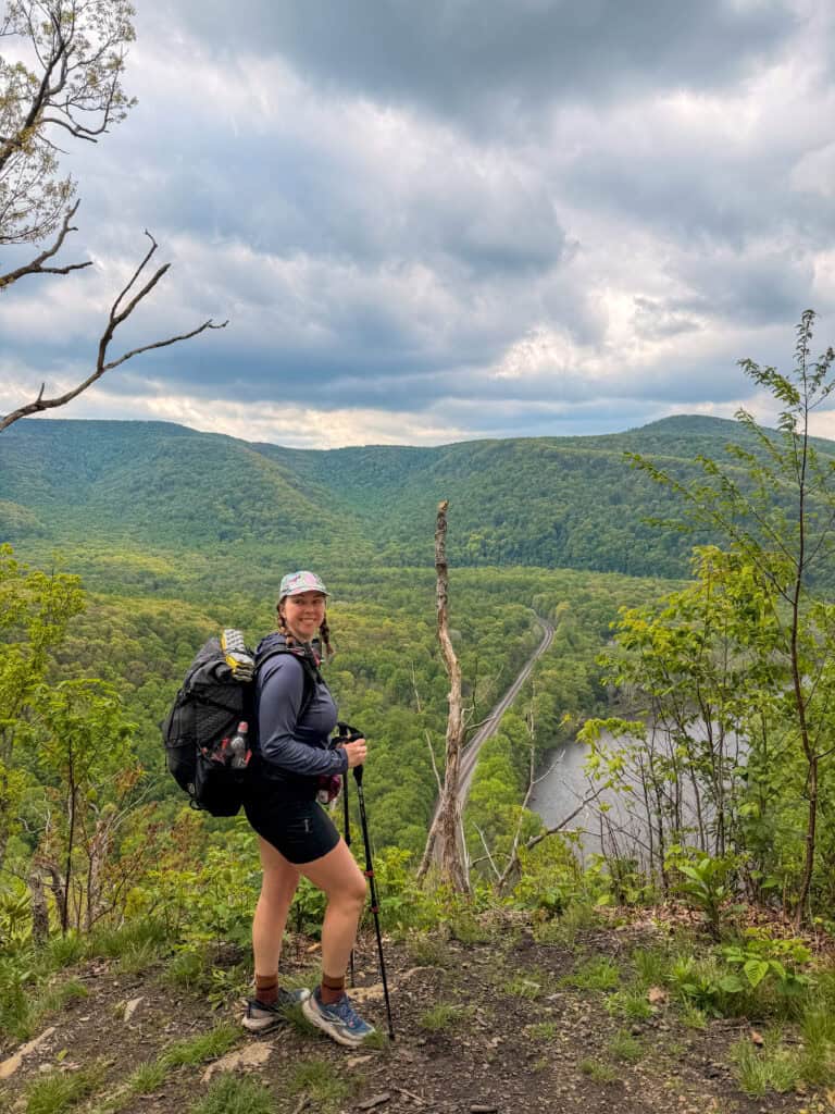
This was one of my favorite days on the entire trail. Highlights include the famous Beam Rocks overlook (an awesome spot for your lunch if you’re coming from Rte 30 Shelter) and crossing the Laurel Highlands Hiking Trail bridge over Interstate 70—the very bridge that inspired me to hike this trail in the first place after years of driving beneath it on family visits to Pennsylvania.

Day 4: Route 31 Shelter Area to Route 653 Shelter Area
Mileage: 14 Miles
Day four brought a much-needed morale boost in the form of Highlands Market, located a short road walk (less than .2 mi) off trail before Seven Springs. If you’re carrying all your food from the start, this makes a great place to grab a hot meal and restock snacks
This section also passes through Seven Springs Ski Resort and includes the highest elevations of the trail before continuing south toward Route 653 Shelter Area. The Ski resort looked quite closed when I passed through in May, but I’ve heard of other hikers stopping to grab a beer and burgers from one of the resort restaurants that appear to be open during the non-ski season.

Day 5: Route 653 Shelter Area to Ohiopyle Shelter Area
Mileage: 12 Miles
The trail continues through beautiful forests, rock formations, and increasingly steep descents as you work your way toward Ohiopyle. This was one of my favorite shelter areas of the trip and the perfect place to spend a final night on trail.
Thinking of skipping ahead to the Southern Terminus? Just be warned that it’s 18.5 miles from Rte 653 to the Ohiopyle terminus and you’re gonna be doing a LOT of brutal up and down, especially in those last 6 miles. But if you’re up for a challenge, its a good way to shave a night off this itienrary.

Day 6: Ohiopyle Shelter Area to Ohiopyle State Park
Mileage: 6.3 Miles
Your final day may be short, but the trail still has a few surprises in store.
The last miles feature two notoriously steep climbs and descents known affectionately as the “Dolly Partons” or “Killer Boobs” (because the elevation profile looks like, well, boobs) before rewarding hikers with a spectacular overlook of the Youghiogheny River Gorge.
From there, it’s a final descent into Ohiopyle State Park and the official southern terminus of the Laurel Highlands Hiking Trail.

More LHHT Itineraries
A Better 6-Day / 5 Night LHHT Itinerary
If you aren’t running from work to try and make it to your shuttle by late-afternoon like I was, then THIS is the itinerary I’d actually suggest for the perfect LHHT 6-Day and 5-Night itinerary. This version avoids the hellish 19-mile Day 2, but still snags a spot at all of my favorite shelter areas.
| LHHT Day | Mileage |
|---|---|
| Day 1: Seward Trailhead (Mile 70) to Rte 271 Shelter Area (Mile 56.9) | 13.1 Miles |
| Day 2: Rte 271 Shelter (Mile 56.9) to Rte 30 Shelter Area (Mile 46.5) | 10.4 Miles |
| Day 3: Rte 30 (Mile 46.5) to Rte 31 Shelter Area (Mile 32.5) | 14 Miles |
| Day 4: Rte 31 (Mile 32.5) to Rte 653 Shelter Area (Mile 18.5) | 14 Miles |
| Day 5: Rte 653 Shelter Area (Mile 18.5) to Ohiopyle Shelter Area (Mile 6.3) | 12.2 Miles |
| Day 6: Ohiopyle Shelter Area to Ohiopyle Trailhead | 6.3 Miles |
5-Day / 4 Night LHHT Itinerary
Want a quicker pace? If you’re prepared for some bigger mileage days, here’s a 5-day and 4-Night LHHT itinerary that I would recommend:
| LHHT Day | Mileage |
|---|---|
| Day 1: Seward Trailhead (Mile 70) to Rte 271 Shelter Area (Mile 56.9) | 13.1 Miles |
| Day 2: Rte 271 Shelter (Mile 56.9) to Turnpike Shelter (Mile 38.2) | 18.7 Miles |
| Day 3: Turnpike Shelter (Mile 38.2) to Grindle Shelter (Mile 24) | 14.2 Miles |
| Day 4: Grindle Shelter (Mile 24) to Ohiopyle Shelter (Mile 6.3) | 17.7 Miles |
| Day 5: Ohiopyle Shelter Area (Mile 6.3) to Ohiopyle Trailhead (Mile 0) | 6.3 Miles |
4-Day / 3 Night LHHT Itinerary
Do you hate your knees? Or perhaps you only have a long weekend to pull off 70-miles? Either way, it’s possible to do the LHHT, assuming that you’ve already got seasoned trail legs and backpacking experience. I do know people who have done this. There’s a few ways you can puzzle-piece 3-nights for this trail, here’s just a suggestion:
| LHHT Day | Mileage |
|---|---|
| Day 1: Seward Trailhead (Mile 70) to Rte 271 (Mile 56.9) | 13.1 Miles |
| Day 2: Rte 271 Shelter (Mile 56.9) to Turnpike Shelter (Mile 38.2) | 18.7 Miles |
| Day 3: Turnpike Shelter (Mile 38.2) to Rte 653 (18.5) | 19.7 Miles |
| Day 4: Rte 653 (Mile 18.5) to Ohiopyle Trailhead (Mile 0) | 18.5 Miles |

What to Pack for the Laurel Highlands Hiking Trail
You don’t need any specialized gear list to hike the Laurel Highlands Hiking Trail. In fact, I veered towards ultralight on this hike (you can see my complete gear-list on Lighterpack, here) with a sub-12lb base weight. Meanwhile, my friend Tory has thru-hiked this with a 20lb+ base weight.
If you’re looking for a good breakdown of beginner-accessible backpacking gear, here are my favorite recommendations.
No matter what, here are some gear tips from the LHHT that I learned the hard way.

What Should I Bring For the Shelters?
Shelter camping means you get to skip packing the tent. Instead, I opted for a large ground sheet (or in my case, ultralight tyvek sheet) to protect my sleeping pad from the wood floor, my Thermarest sleeping pad, pillow, and sleeping quilt.
You’ll also want to bring a lighter (this tiny Bic works great) and some firestarter cubes (these weighed basically nothing) if you plan on having a fire at night (and you should).
A string of lights for a cozier setup would be on my packing list for next time.
Need help packing for your backpacking trip? Get my favorite backpacking gear suggestions that I use and love on the trail, delivered right to your inbox! Plus a backpacking checklist so you always pack exactly what you need!
Rain Gear Is Mandatory
It rained every day of the LHHT. For 2 of those days, it rained basically the entire day. And if you know Western Pennsylvania, that’s hardly unusual.
Even if the forecast looks promising, pack a quality rain jacket and keep your gear your dry with a pack cover or liner (my preference). Depending on the season and your preference, you may also appreciate rain pants. Between frequent rain, mud, and wet vegetation brushing against the trail, there’s a good chance you’re going to get wet at some point.
The good news? Every shelter area has fireplaces and hooks, making it much easier to dry out your gear at the end of the day
Footwear Matters
Rocky tread, roots, and uneven terrain are constant companions for much of the trail. By the end of my second day, after nearly 20 miles of hiking in the rain, my feet were definitely feeling it.
Whatever shoes you choose, make sure they’re well broken in before your trip. Trail runners are extremely popular on the LHHT, and while my feet got wet, my shoes also dried overnight, which a heavy waterproof boot would never do.
I would also advise bringing at least 1, ideally 2 extra pairs of socks (3 pairs total). There’s nothing worse than having to put wet socks back on morning after morning.
Trekking Poles Are Worth It
If you’re on the fence about bringing trekking poles, bring them.
The combination of rocky terrain, steep descents, muddy trail conditions, and occasional creek crossings makes them incredibly useful. I found myself relying on mine constantly, especially during the steep downhill sections approaching Ohiopyle.
Your knees will thank you.
Water Capacity Recommendations
I’d recommend carrying the ability to haul at least 3 liters of water, and potentially closer to 5 liters during hot summer weather or on longer stretches between reliable sources.
I carried my trusty Sawyer Squeeze, 1 1L CNOC thru-bottle and 2 1LSmartwater Bottles, and a 2L CNOC Vecto Bag.

Wildlife, Safety & Solo Hiking on the LHHT
One of the things I loved most about the Laurel Highlands Hiking Trail was how remote it felt. Despite hiking during the busy summer season, there were days when I saw only a handful of other people—or none at all.
That solitude is part of the trail’s charm, but it also means hikers should be prepared and practice good backcountry safety.
Black Bears
The Laurel Highlands are home to healthy populations of black bears. While bear encounters are relatively uncommon, proper food storage is still essential.
Fortunately, every Shelter Area now has bear hang poles installed for hikers to use. Take advantage of them. Store all food, scented toiletries, trash, and other smellables on the bear hang every night, even if you’re sleeping in one of the shelters. A few extra minutes of effort helps keep both hikers and bears safe.

Ticks
If there’s one piece of wildlife you should genuinely worry about on the LHHT, it’s ticks.
Pennsylvania has high rates of Lyme disease, and ticks are common throughout the Laurel Highlands, especially during spring and summer. Wear long pants if conditions allow, use insect repellent, pretreat your gear and apparel with permethrin, and perform thorough tick checks at the end of every day.
Trust me: the ticks are far more likely to ruin your trip than a black bear.
Hunting Seasons & State Game Lands
Portions of the Laurel Highlands Hiking Trail pass near or through State Game Lands where hunting is permitted.
If you’re hiking during Pennsylvania hunting seasons, wear bright colors and consider carrying a blaze orange hat or vest. It’s a simple precaution that can help improve your visibility to hunters.
Always check current hunting regulations and seasons before your trip, particularly if you’re planning a fall hike.
Solo Hiking Considerations
If you’re nervous about solo backpacking, you’re not alone.
In fact, one of the most memorable parts of my thru-hike had nothing to do with the scenery. My first night on the LHHT was the first time in my life that I had ever backpacked completely alone without another camper in sight.
If you’re going solo, here are some important safety tips: Carry a way to communicate in an emergency, tell someone your itinerary, and trust your instincts. But if you’ve been curious about trying your first solo backpacking trip, the Laurel Highlands Hiking Trail is a pretty great place to start.
I personally always carry a Personal Locator Beacon / Satellite communicator like my Garmin InReach Mini 2 (monthly subscription required). With this device I can send text messages, track my hike, view offline maps, or hit the SOS button to contact search and rescue in a true emergency.
Sometimes the most rewarding part of a hike isn’t the scenery—it’s discovering that you’re capable of more than you thought.

Final Thoughts on the Laurel Highlands Hiking Trail
As someone who has spent most of my backpacking career hiking in California, Washington, Oregon, and the American West, I wasn’t sure what to expect from a 70-mile trail tucked away in the Pennsylvania highlands.
What I found was a trail full of surprises: moss-covered rock formations, beautiful forests, remarkable solitude, and one of the most comfortable shelter systems I’ve ever used.
The Laurel Highlands Hiking Trail challenged me, humbled me, soaked me, and completely won me over.
If you’re looking for an approachable thru-hike, a training trail for something bigger, or simply a chance to experience one of Pennsylvania’s best backpacking adventures, I can’t recommend the Laurel Highlands Trail highly enough.
More Backpacking Adventures
15 Backpacking Tips for Your First Backpacking Trip
The Complete Guide To New Hampshire’s AMC Huts: The Ultimate White Mountains Adventure
Hiking the Trans Catalina Trail: Everything You Need to Know
Looking for more
