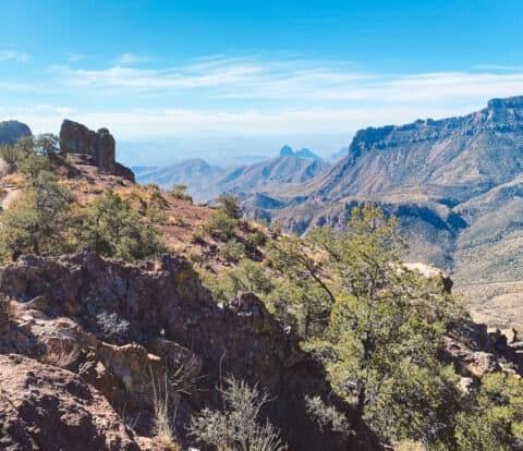
Ross Maxwell Scenic Drive is a must-see in Big Bend National Park, and in my opinion, one of the most scenic drives in any National Park. This drive is a blend of rugged hikes, historical sites, and panoramic views that encapsulate the best of what makes this Far West Texas wilderness so iconic.
This guide to driving Ross Maxwell Scenic Drive in Big Bend National Park is packed with all the essential information, from must-see stops to practical tips for a safe and easy trip. Buckle up and get ready for an unforgettable expedition along the Ross Maxwell Scenic Drive.
Disclosure: This page may contain sponsored content or affiliate links, including Amazon links, where I earn a small commission from any purchase – at no extra cost to you. This commission helps keep Brooke In Boots up and running. As always, all opinions are 100% honest and my own!
Highlights of Ross Maxwell Scenic Drive
A drive on Ross Maxwell Scenic drive is a must-do on any trip to Big Bend National Park. Here’s a quick look at some of the highlights you can visit on this iconic drive:
- Sam Nail Ranch
- Sotol Vista Overlook
- Lower Burro Mesa Pouroff Trail
- Tuff Canyon
- Santa Elena Canyon
This post covers each of these incredible sights and hikes in detail, below. I’ve also included my favorite Big Bend planning tips, information on picnic areas and visitor services, directions, and important safety information when planning your adventure on Ross Maxwell Scenic Drive.
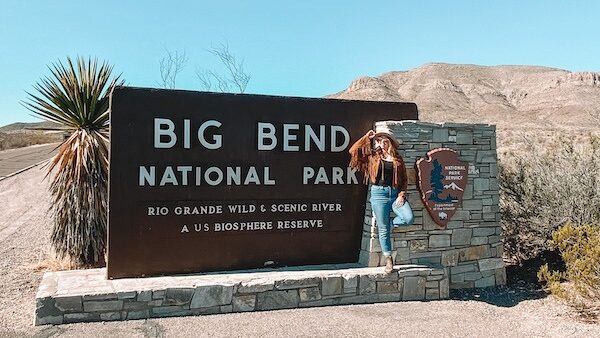
Visiting Big Bend National Park
Ross Maxwell Scenic Drive is located in Big Bend National Park, on the Rio Grande river in Far West Texas. The nearest town to Big Bend is Terlingua, Texas.
In Big Bend, you’ll explore rugged mountains, wide open desert vistas, eat some incredible Tex-Mex, and explore a true slice of the last of the Wild West.
Check out These Posts for More Resources on Visiting Big Bend
3 Day Big Bend Itinerary Guide
Hiking Big Bend: 16 Can’t-Miss Hikes in Big Bend National Park
Driving Ross Maxwell Scenic Drive in Big Bend National Park
Best Lodging Near Big Bend National Park
How to Visit Boquillas Del Carmen Mexico from Big Bend National Park
Entrance Fees & Reservations in Big Bend National Park
Big Bend charges an entrance fee of $30 per vehicle (Credit / Debit card only – no cash). Your entrance fee permit is valid for 7 days. There are no reservations or timed-entry permits required to visit Big Bend.
Traveling to more than 2 National Parks or National Forests this year? Purchase an America the Beautiful National Parks Pass for $80, which covers entrance fees at all National Parks and NPS managed sites.
Is Big Bend National Park Safe?
Big Bend National Park is generally safe for visitors, and we personally never felt unsafe while visiting Big Bend, or across the border in Boquillas del Carmen, Mexico.
But like all National Parks, it’s important to be mindful of the natural hazards present in the desert environment. The park is home to diverse wildlife, including bears, mountain lions, and venomous reptiles, so it’s essential to follow safety guidelines and be vigilant when hiking or camping!
Additionally, visitors should be prepared for the remote and rugged terrain, and always carry sufficient water and emergency essentials while exploring the park, even on paved roads like Ross Maxwell Scenic Drive.
I personally always carry a Personal Locator Beacon / Satellite communicator when visiting a National Park like my Garmin InReach Mini 2 (monthly subscription required). With this device I can send text messages, track my hike, view offline maps, or hit the SOS button to contact search and rescue in a true emergency.
Finally, Big Bend is located on the United States border with Mexico. Despite what you see on the news, Big Bend is not overrun with drug traffickers, human smugglers, and bandits. Like San Diego or El Paso, it is a relatively safe area with some unique issues.
Although rare, illegal crossings and drug smuggling does occur from time to time. If you see anything that looks suspicious, keep away, note the location, and call 911 or alert NPS and CBP staff when possible. Learn more about visiting a border area, here.
If you see people in distress, especially anyone injured or asking for water, immediately contact authorities. Lack of water is a life-threatening emergency in the desert.
Overall, with proper preparation and by staying aware of your surroundings, I believe visitors can have a safe and enjoyable experience at Big Bend National Park.
Want to learn more about planning an epic National Parks trip? Grab my free Ultimate National Parks Planning Guide, including 70+ pages of National Park packing checklists, planning tips, and everything you need to know to start planning a trip to all 63 National Parks!
About Ross Maxwell Scenic Drive in Big Bend
Ross Maxwell Scenic Drive is a picturesque road that winds through the heart of Big Bend National Park. The entire Ross Maxwell Scenic Drive spans approximately 30 miles (30.9 to be exact) from the Chisos Mountains to the Rio Grande River on the Park’s southwest border with Mexico.
A scenic drive on this road is a must-do experience when visiting Big Bend National Park!

Ross Maxwell Scenic Drive is an out-and-back drive on a paved road, and accessible to any passenger vehicle or SUV. The drive does close periodically in winter due to ice and snow, and during flash flooding, usually in summer and early fall.
You don’t need a 4WD or AWD vehicle to drive Ross Maxwell Scenic Drive, unless you plan on taking the (totally optional) unpaved Old Maverick Road back.
How Long Does it Take to Drive Ross Maxwell Scenic Drive?
Without stopping it takes about 45 minutes, one way, to drive the entire length of Ross Maxwell Scenic Drive.
With stops at the many trailheads, viewpoints and points of interest along the way, you can easily spend a few hours to an entire day exploring Ross Maxwell Scenic Drive.
Directions to Ross Maxwell Scenic Drive from Panther Junction Visitor Center
To reach Ross Maxwell Scenic Drive from Panther Junction Visitor Center, head southwest on Park Route 12, which is the primary road from the Visitor Center.
Continue along this route as it winds through the desert landscape for approximately 13 miles. Keep an eye out for the signage indicating the turning point for Ross Maxwell Scenic Drive. Once you reach the junction, take the left turn onto the Scenic Drive, and you’re on your way.
This route will lead you directly through some of the most picturesque areas of the park, through the Chihuahuan Desert’s vast expanse and ending at the magnificent Santa Elena Canyon after about 30 miles of scenic driving.
Take this info to-go! The Big Bend Itinerary Guide has your perfect 1, 2, or 3 day Big Bend trip completely planned for you! With over 20 pages of detailed hiking guides, printable daily itineraries, lodging and dining suggestions and more, you can spend less time stressing and more time making epic memories! Check it out, here.
Directions to Ross Maxwell Scenic Drive from Terlingua, Texas
From the rustic desert town of Terlingua, Texas, make your way towards Big Bend National Park’s western entrance. Follow State Route 170 east to State Highway 118 and make a right, following 118 to the western entrance of the Park.
Inside the Park, continue for about 20 miles on State Highway 118, which becomes Panther Junction Road.
Keep an eye out for the signage indicating the turning point for Ross Maxwell Scenic Drive. Once you reach the junction, take a right turn onto the Scenic Drive.
Picnic Areas & Visitor Services On Ross Maxwell Scenic Drive
Big Bend is a remote park where services can be few and far between. Thankfully, there are a number of picnic areas, restrooms, and even a Visitor Center and campground located on Ross Maxwell Scenic Drive.
There is no gas on Ross Maxwell Scenic Drive. The nearest gas station is located at Panther Junction, inside the Park, and Terlingua, Texas, outside the Park.
Picnic Areas are located at the historic Castolon Store, Cottonwood Campground, and Santa Elena Canyon Trailhead.
Restrooms are located at the Sotol Vista Overlook, Castolon Visitor Center, and Cottonwood Campground. Vault toilets are located at the Santa Elena Canyon Trailhead.
The Castolon Visitor Center is located about 20 miles from the start of Ross Maxwell Scenic Drive (8 miles to Santa Elena Canyon). This is the only Visitor Center in the area. Inside you can find educational exhibits and a ranger to answer any questions or share updates on trail conditions.

The Best Stops on Ross Maxwell Scenic Drive
Ross Maxwell Scenic Drive has dozens of trails, historic sites and viewpoints to choose from. Depending on how much time you have to spend in Big Bend, you’ll likely have to pick and choose a handful of stops on your drive.
Below are some of our favorite stops along Ross Maxwell Scenic Drive. Some, like the historic sites and shorter trails, you might want to skip if you’re short on time. But whatever you do, don’t miss Sotol Vista Overlook and especially Santa Elena Canyon trail!
These stops are listed in the order you’ll find them driving south along the scenic drive, towards Santa Elena Canyon.
Map of the Best Stops on Ross Maxwell Scenic Drive
How to Use This Map: Click the Icons on the map to see more information about each location. Click the star at the top of the map to add the map to your Google Maps account.
Sam Nail Ranch
Time stands still at Sam Nail Ranch, the first stop on Ross Maxwell Scenic Drive. Park your car and walk the short loop trail, about 0.3 miles, to the modest ruins of a modest ranch, once owned by the Nail family.
A working windmill still pumps water here, making this a mini oasis (although still a very dry one) in the middle of Big Bend’s desert.

Sotol Vista Overlook
Look for the turnoff to Sotol Vista Overlook, about 5 miles south of Sam Nail Ranch, 8 miles from the start of Ross Maxwell Scenic Drive.
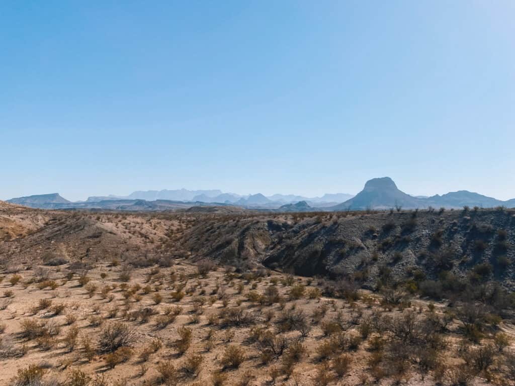
A short paved road winds up the side of the mountain to the Sotol Vista Overlook parking area. This spot is hands down one of the best views in Big Bend National Park, and a particularly beautiful spot to watch sunrise and sunset. From here you can see the vast Chihuahuan Desert and spot massive Santa Elena Canyon in the distance.
FYI, this spot has one of the few bathrooms along the Scenic Drive.
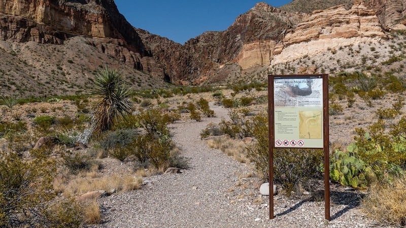
Lower Burro Mesa Pouroff Trail
1 mi / 30 Min / Easy / AllTrails
About 3 miles south of Sotol Vista, don’t miss the turn off for Lower Burro Mesa Pouroff Trail. This short trail twists between the volcanic hills and rugged rock formations that define this area of the Park.
The trail ends in a small canyon that is dry most of the year but becomes a roaring river during summer. Make sure to avoid this area during heavy rain, as flash floods are possible.
You can also access this area from the Upper Burro Mesa Trail, located between Sam Nail Ranch and Sotol Vista. The Upper trail leads to the top of the canyon wash.
Chimneys Trail
4.6 Miles / 2 Hours / Moderate / AllTrails
About 1 mile from the turnoff for Lower Burro Mesa, this moderate out-and-back trail is a classic Big Bend desert hike. Along this 4.6 mile trail, take in wide rugged vistas, volcanic rock formations, and even Native American petroglyphs etched high on the rocks.
The trail is mostly flat, but the loose sandy rock can be tiring to walk in. Make sure to bring sturdy hiking shoes for this one!
There is little to no shade on this desert hike. Plan to arrive early when temps are low, and bring plenty of water.

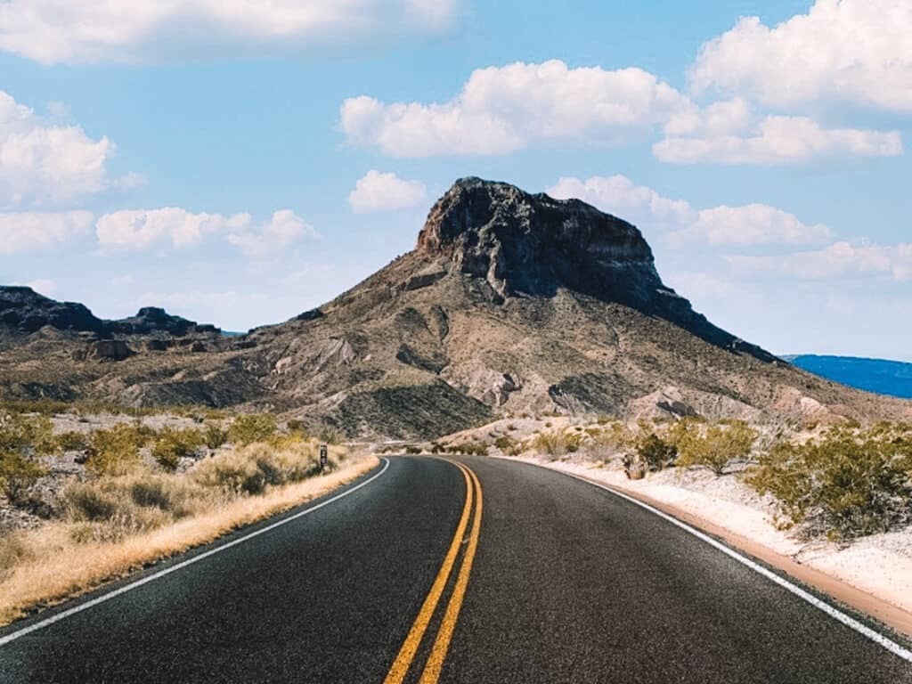
Mule Ears Overlook
Another 3 miles past the Chimneys Trail (16 miles from the start of Ross Maxwell Scenic Drive), don’t miss the short paved road to the Mule Ears Overlook. In the distance you’ll see Mule Ears Peaks, a pair of distinctive volcanic spires that look like, you guessed it, pointy mule ears.

Castolon Visitor Center and Historic District
The Castolon Visitor Center is closed in the Summer. Check hours and seasons, here.
The Castalon Historic district houses various historic structures from the Park’s long history of settlers, ranchers, military camps, Texas Rangers and Wild West bandits.
In 2019 a wildfire jumped the Rio Grande a short distance from here and destroyed several buildings at Castolon, including the Visitor Center.
A temporary visitor center and restrooms are now housed in an adjacent building while the Park determines how to restore and preserve the site.

Tuff Canyon
1mi / 1 Hr / Easy / AllTrails
Look down into this relatively small, but interesting canyon, or explore the canyon from the bottom along the Tuff Canyon Trail. This 1 mile out-and-back trail follows the sandy, rocky wash of the canyon before a dead end, takes about 1 Hour to complete, and is kid-friendly.
Update: As of February 2023, the Tuff Canyon trail closed indefinitely due to a rockfall. You can still look into the Canyon from the overlook at the parking area. Check Park updates and trail info, here.
Santa Elena Canyon
Ross Maxwell scenic drive ends at Santa Elena Canyon, one of the most iconic spots in the park and the end of the road for Ross Maxwell Scenic Drive. This was our second favorite spot in Big Bend (after the Lost Mine Trail). You’ll definitely want to get out of the car here.
There’s a large parking lot with picnic tables and vault toilets at the trailhead.
Santa Elena Canyon Trail: 1.4 Miles / 200′ Elevation Gain / Easy / AllTrails
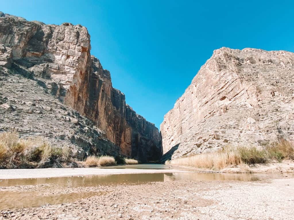
A short dirt and boardwalk trail leads from the parking area to the mouth of the canyon where the Rio Grande has carved a massive canyon, 8 miles long and 1,500 feet deep.
A short but steep series of stone switchbacks ascend part-way up the canyon before gradually descending to the water’s edge. The trail follows the shady and lush river’s edge, until the canyon walls meet the water.
When water levels are low, adventurous hikers continue upriver from here, using the river as a trail. Be very careful as river currents can be deceptively strong, and swimming here is not permitted. At the very least, bring a pair of water-sandals and dip your toes into this iconic river the defines the park.
This trail may be impassable after intense rain. Check with Rangers about current conditions, particularly if you are visiting in Summer or Fall.

Old Maverick Road
You can return the way you came, via Ross Maxwell Scenic Drive, or return via unpaved Old Maverick Road. This 14-mile dirt road is accessible for most cars, although low-clearance vehicles should be especially cautious. RVs and oversized vehicles are not permitted. The road winds through the Terlingua Badlands, passing several historic structures and desert vistas.
The road takes approximately 1 hour before joining the paved road out of the park at Maverick Junction.
Take this info to-go! The Big Bend Itinerary Guide has your perfect 1, 2, or 3 day Big Bend trip completely planned for you! With over 20 pages of detailed hiking guides, printable daily itineraries, lodging and dining suggestions and more, you can spend less time stressing and more time making epic memories! Check it out, here.
The Best Time to Drive Ross Maxwell Scenic Drive in Big Bend
Big Bend is a desert, which means that you’ll probably want to visit late Fall – early Spring, and whatever you do avoid visiting during peak summer heat! The weather in Big Bend changes dramatically by the season.
If it’s your first visit to Big Bend National Park, I recommend visiting in Spring (March – April). Thanks to the mild temperatures and low rainfall, spring is considered the “best” time to visit Big Bend. It’s also the most crowded time to visit Big Bend, so make sure you book your lodging reservations well in advance. During spring, temperatures range from the 30’s at night and into the 80’s and 90’s during the day.
Summer (May, June, July, August, September) in Big Bend is long and hot. Temperatures usually spike well above 100 degrees during the day. Plan hikes for early morning, bring plenty of water, and stay OFF the trails during the afternoon! Thunderstorms and flash floods are also common from May to September.
Hikers have died of heat-related illness in this park – don’t let it be you!
If you aren’t afraid of a little rain, Fall (September, October, November) makes for an excellent time to plan a Big Bend itinerary. Daytime are back in the 80’s and 90’s, and the rainy season continues through September. Visit in October for a chance to see some fall foliage in the Chisos Mountains!
Finally, winter (December, January, February) is mild and another best time to visit Big Bend National Park. Snow and freezing conditions are possible, especially in the Chisos Mountains. If you visit during winter, be prepared for all kinds of conditions, from snowstorms to sunny 70 degrees!
Tips for Driving Ross Maxwell Scenic Drive
Before setting off, here are a few important tips to know about planning the perfect drive on Ross Maxwell Scenic Drive.
Arrive early. Arrive in the Park as early as possible, ideally before 7AM to make the most out of your day and avoid the crowds. If you plan on arriving later, its a good idea to drive directly to Santa Elena Canyon, which is the most crowded stop on the scenic drive, then work your way backwards to the other stops.
Parking is limited. Because Big Bend isn’t (or wasn’t) a hugely visited Park, most trailhead parking lots and viewpoints only fit a few cars. This is especially true in the Chisos Mountains area, but can happen along the Scenic Drive as well.
Safety Tips for Driving Ross Maxwell Scenic Drive
There is no cell service in most of Big Bend, including along Ross Maxwell scenic drive. Make sure to download any maps or trail directions you might need ahead of time!
I personally always carry a Personal Locator Beacon / Satellite communicator when visiting a National Park like my Garmin InReach Mini 2 (monthly subscription required). With this device I can send text messages, track my hike, view offline maps, or hit the SOS button to contact search and rescue in a true emergency.
Bring plenty of water! This is a desert park and hikes are dry and hot, even in the winter. Bring more water than you think you’ll need, at least 1 Liter for every hour you plan on hiking. Make sure to refill your water bottles frequently at visitor centers there are no natural water sources on the trails.
You should also carry emergency essentials, like emergency blankets, water, and salty snacks in your car. This is a remote park and rescue or a tow truck may be hours away if your vehicle breaks down.
Watch out for flash flooding, especially if you’re planning your trip between May and September, when thunderstorms are common. Low-water crossings may become impassable, and previously dry washes can quickly turn into raging torrents. If you encounter water flowing across the road, do not attempt to cross it.
Keep an eye out for animals, particularly around dawn and dusk when creatures like coyotes and javelinas are most active. We saw plenty of both during our trip to Big Bend!
Ross Maxwell Scenic Drive encapsulates the rugged and raw beauty that makes Big Bend one of my favorite National Parks. For history buffs and seasoned hikers alike, there’s something for everyone here.
A drive on Ross Maxwell Scenic Drive is a must-do when visiting Big Bend National Park. Check out more things to do on your visit to Big Bend in this Ultimate 3 Day Big Bend Itinerary Guide.
Explore More National Parks
Get the Ultimate National Parks Planning Guide (for free!) sent to your inbox, full of important planning information, printable packing lists, and the best things to do in all 63 National Parks.
Big Bend: Epic Big Bend Itinerary Guide
Bryce Canyon: One Epic Day in Bryce Canyon National Park
Cuyahoga Valley: 17 Best Things to Do in Cuyahoga Valley National Park
Great Smoky Mountains: The Ultimate Great Smoky Mountains Itinerary in 2 Days
Joshua Tree: The Perfect Day Trip to Joshua Tree National Park
New River Gorge: The Best Hikes in New River Gorge National Park
Yosemite: Epic Yosemite 2 Day Itinerary – How to Spend 2 Perfect Days in Yosemite