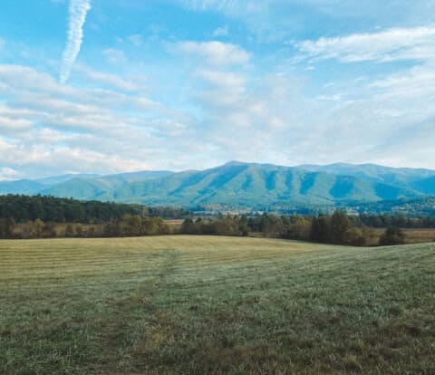
Planning a trip to Great Smoky Mountains? This beautiful wilderness is the most popular National Park in the US, largely thanks to its convenient location.
I got to visit the Smokies 3 times while living on the East Coast. Between the endless hiking opportunities and scenic drives, it’s a park that will keep you coming back again and again.
If you are flying to Great Smoky Mountains National Park, the closest airports are Knoxville McGhee Tyson Airport in Tennessee and Asheville Regional Airport in North Carolina. There are also multiple international airports, like Charlotte and Atlanta, within a reasonable driving distance to the Smokies.
Driving to the Smokies? Great Smoky Mountains is easily accessible from multiple highways. You can also check out the scenic Foothills Parkway, or iconic Blueridge Parkway (my personal favorite) for an iconic National Park road trip.
This comprehensive guide below covers everything you need to know about how to get to Great Smoky Mountains National Park. I’ve included important information on the closest airports to Smoky Mountains, driving directions, and winter driving information.
Disclosure: This page may contain sponsored content or affiliate links, including Amazon links, where I earn a small commission from any purchase – at no extra cost to you. This commission helps keep Brooke In Boots up and running. As always, all opinions are 100% honest and my own!
Where is Great Smoky Mountains National Park Located?
Great Smoky Mountains National Park is located in the Southeastern United States, encompassing the stunning ridge of mountains on the border of Tennessee and North Carolina.
The Great Smoky Mountains, or “the Smokies” are part of the Blue Ridge mountains, which is a section of the greater Appalachian Mountain chain.
Great Smoky Mountains National Park is located approximately halfway between the cities of Knoxville, Tennessee and Asheville, North Carolina.
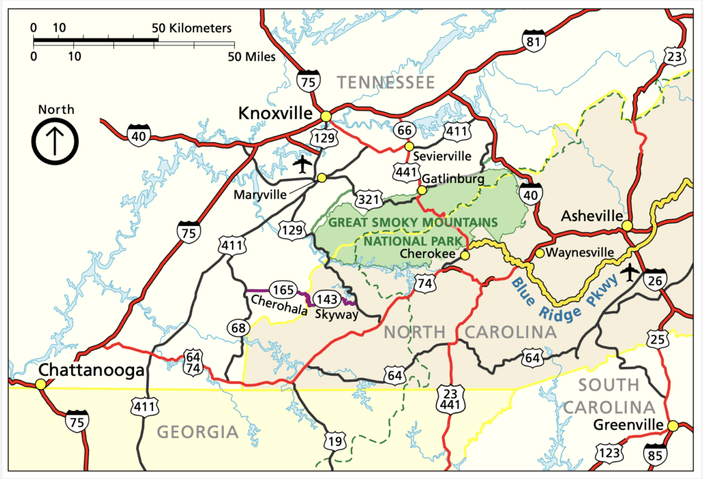
The Park is located directly outside the towns of Gatlinburg, Tennessee, Townsend, Tennessee and Cherokee, North Carolina. Because of their convenient locations and tons of hotels, home rentals, restaurants, and activities, most people will stay in one of these towns while visiting the Smokies.
| City | Closest Park Visitor Center | Distance |
|---|---|---|
| Gatlinburg, Tennessee | Sugarlands Visitor Center | 4.5 Mi / 15 Minutes |
| Townsend, Tennessee | Cades Cove Visitor Center | 16.8 Mi / 45 Minutes |
| Cherokee, North Carolina | Oconaluftee Visitor Center | 3.5 Mi / 10 Minutes |

Want to take this itinerary to go? The 3 Day and 2 Day Great Smoky Mountains Itineraries include over 20 pages of daily itineraries, an in-depth Cades Cove guide, a detailed guide to the best hikes in Great Smoky Mountains, plus lodging and dining information, and tips for how to beat the crowds! Get your guide and learn more, here.

Closest Airports to Great Smoky Mountains
If you aren’t road tripping directly from home to the Smokies, you’ll need to fly to one of these nearest airports to the Smoky Mountains.
Map of the Closest Airports to Great Smoky Mountains
How to Use This Map: Click the Icons on the map to see more information about each location. Click the star at the top of the map to add the map to your Google Maps account.
Closest Airport to Gatlinburg, TN
Knoxville McGhee Tyson Airport
The nearest airport to Gatlinburg, Tennessee is Knoxville McGhee Tyson Airport. Since most visitors will stay in and around Gatlinburg and nearby Pigeon Forge, TN, Knoxville is my pick for the best closest airport to Great Smoky Mountains.
Knoxville is a decent sized city with plenty of hotel options if you need to spend the night before or after your flight. It also has plenty of rental car options – a must for any Great Smoky Mountains itinerary – and is only about an hour from the Park!
Distance: 40 Miles to the Sugarlands Visitor Center / 1 Hour Drive
Airlines: Allegiant Air, American Airlines, American Eagle, Delta, Frontier, United
Rental Cars: Alamo, Avis, Budget, Enterprise, Hertz, National, Dollar, Payless
>> Click here to book your flight to Knoxville McGhee Tyson Airport
Closest Airport to Cherokee, NC
Asheville Regional Airport
The closest airport to Cherokee, North Carolina (Oconaluftee Entrance) is Asheville Regional Airport, in Asheville, North Carolina. This is a smaller airport in North Carolina, meaning that you’ll probably pay more and have fewer rental car options.
But if you plan on driving the Blue Ridge Parkway and exploring Asheville’s hip mountain town culture, it’s a great choice!
Distance: 88 Miles to Sugarlands Visitor Center / 2 Hours Drive
Airlines: Allegiant, American Airlines, Delta, JetBlue, SunCountry, United
Rental Cars: Avis, Budget, Enterprise, Hertz, National, Alamo, Dollar, and Thrifty
>> Click here to book your flight to Asheville Regional Airport

Closest International Airport to Great Smoky Mountains
There are several major international airports located within driving distance of Great Smoky Mountains. If you’re looking to save money and have the best flight options, these international airports near the Smoky Mountains are likely your best choice.
The closest major airports to Gatlinburg, Tennessee and Great Smoky Mountains, are:
| Airport | Nearest Visitor Center | Distance |
|---|---|---|
| Greenville-Spartanburg International Airport (GSP) | Oconaluftee | 120 Mi / 2 Hours 10 Minutes |
| Charlotte Douglas International Airport (CLT) | Oconaluftee | 165 Miles / 3 Hours |
| Hartsfield-Jackson Atlanta International Airport (ATL) | Oconaluftee | 175 Miles / 3 Hours |
Greenville – Spartanburg International Airport in South Carolina
The Greenville-Spartanburg Airport (GSP) in South Carolina is the closest major airport to Great Smoky Mountains National Park. It’s a convenient option if you’re traveling from outside the Southeast, and offers plenty of nearby hotels and rental cars.

If you need to pick up camping or hiking supplies, there’s an REI conveniently located in Greenville, less than 15 minutes from the airport.
Distance: 122 Miles to Oconaluftee Visitor Center / 2 Hours Drive
Airlines: Allegiant, American, Breeze, Delta, Southwest, United
Rental Cars: Alamo, Avis, Budget, Enterprise, Hertz, National
>> Click here to book flights to GSP

Charlotte Douglas International Airport in North Carolina
Charlotte Douglas International Airport (CLT) is a convenient, and often inexpensive, Great Smoky Mountains airport.
In Charlotte, North Carolina, you’ll find plenty of hotels, good southern food, and outdoor gear suppliers like REI.
Looking for the ultimate scenic drive? From Charlotte, you can drive towards Asheville, North Carolina and spend hours – or days – exploring the Blue Ridge Parkway. This scenic drive travels 469 miles from Shenandoah National Park in Virginia, to Great Smoky Mountains in the South.
Read more about driving the Blue Ridge Parkway to Great Smoky Mountains, below.
Distance: 165 Miles to Oconaluftee Visitor Center / 3 Hours Drive
Airlines: American Airlines, Delta, Frontier, JetBlue, Southwest, Spirit, Sun Country, United, and other international airlines.
Rental Cars: Alamo, Avis, Budget, Dollar, Enterprise, Hertz, National, Sixt
>> Click here to book flights to CLT
Hartsfield Jackson Atlanta International Airport in Georgia
Atlanta Harsfield-Jackson International Airport (ATL) is the largest airport in the United States! At 175 miles away, this isn’t the Smoky Mountain’s closest airport isn’t close, per say, but it is the best airport near Great Smoky Mountains National Park for finding the cheapest flights and rental cars.
I frequently traveled in and out of ATL while we lived in the south, and the drive from Atlanta to Great Smoky Mountains is relatively easy and very scenic – once you get past the horrendous ATL traffic!
There are an unlimited number of hotels, restaurants, outdoor supply stores, and things to do in Atlanta before or after your trip to the Smokies.
Distance: 175 Miles to Oconaluftee Visitor Center / 3 Hours Drive
Airlines: Alaska, American, Delta, Frontier, JetBlue, Southwest, Spirit, United and several international airlines.
Rental Cars: Advantage, Alamo, Avis, Budget, Dollar, Enterprise, Hertz, National, Payless, Sixt
Want to learn more about planning an epic National Parks trip? Grab your FREE Ultimate National Parks Planning Guide. It includes 70+ pages of printable packing checklists, my best planning tips, and everything you need to know to start planning a trip to all 63 National Parks!
Nearest Cities to Smoky Mountains
Despite being one of the largest wilderness areas in the contiguous United States, Great Smoky Mountains National Park is conveniently located near several major cities.
In fact, almost 2/3 of the United States’ population is within a day’s drive of the Smokies, making it the most visited National Park in the United States.
This chart shows the closest large cities to the Smoky Mountains:
| City | Closest Visitor Center | Driving Distance |
|---|---|---|
| Asheville, NC | Oconaluftee Visitor Center | 60 Mi / 1 Hour 15 Minutes |
| Knoxville, TN | Sugarlands & Cades Cove Visitor Centers | 42 Mi / 1 Hour 15 Minutes |
| Charlotte, NC | Oconaluftee Visitor Center | 180 Mi / 3 Hours 15 Minutes |
| Atlanta, GA | Oconaluftee Visitor Center | 165 Mi / 3 Hours 15 Minutes |
| Nashville, TN | Sugarlands & Cades Cove Visitor Centers | 225 Mi / 3 Hours 45 Minutes |
Driving Directions to Great Smoky Mountains
Driving directions to Great Smoky Mountains depend on exactly where you are staying and where you are headed inside this vast park.
However, these general directions will get you to the main Park entrances outside Gatlinburg, Townsend, and Cherokee.
Gatlinburg to Great Smoky Mountains Directions
From Interstate 40, take exit 407 for TN-66 South towards Sevierville/ Pigeon Forge / Gatlinburg. In Sevierville, continue straight onto Highway 441 South. Follow Highway 441 South through Pigeon Forge, where it becomes Highway 321. Follow Highway 321 / 441 through Gatlinburg and into Great Smoky Mountains National Park.
Drivers can also opt to take the Gatlinburg Parkway Bypass. The Bypass skirts around downtown Gatlinburg, which often has heavy traffic.
To take the Bypass, follow Highway 321 / 441 South. Follow signs for National Park / Gatlinburg Bypass. The Bypass leads directly into Great Smoky Mountains National Park, rejoining Newfound Gap Road (Highway 321).

Driving Directions to Townsend Entrance
From I-40 in Knoxville, Tennessee and other points North, take Highway US-129 South towards Alcoa. In Alcoa, keep to the left for TN-35 N/N Hall Rd. Continue on TN-35. In Maryville, follow US-321 North/ TN -73 / Lamar Alexander Parkway to Townsend.
In Townsend, continue straight on TN-73 / Lamar Alexander Parkway into Great Smoky Mountains National Park.
From I-75 south of Knoxville, including Chattanooga, take I-75 North and take exit 376 to merge onto I-140 E toward Maryville. Take exit 11A to to US-129 S/Alcoa Highway towards Alcoa.
In Alcoa, keep to the left for TN-35 N/N Hall Rd. Continue on TN-35. In Maryville, follow US-321 North/ TN -73 / Lamar Alexander Parkway to Townsend.
In Townsend, continue straight on TN-73 / Lamar Alexander Parkway into Great Smoky Mountains National Park.
Driving Directions to Cherokee
From highway I-40 (Asheville, Charlotte, Greensboro and other points North), exit and follow US-74 West towards Waynesville.
Take exit 103 for US-19 toward Maggie Valley/Cherokee. Turn onto US-441 North at Cherokee and follow the road into the park.
From the South (Atlanta, Chattanooga) Follow US-441/US-23 North. At Dillsboro merge on US-74 West/US-441 North. Take exit 74 to merge onto US-441. Follow US-441 through Cherokee and into the park.
Driving the Blue Ridge Parkway to Great Smoky Mountains
While not the most direct way to Great Smoky Mountains, the Blue Ridge National Scenic Parkway is one of America’s most scenic and iconic road trips, and well worth the visit. The Parkway stretches 469 Miles from Shenandoah National Park in Virginia to Great Smoky Mountains National Park, adjacent to the Cherokee, North Carolina entrance.
Road Trippers can drive as little, or as long on the Parkway as their itinerary allows. Popular spots along the Blue Ridge Parkway include Shenandoah, Asheville North Carolina, Peaks of Otter, Linn Cove Viaduct and of course the Great Smoky Mountains.
Learn more about driving the Blue Ridge Parkway and directions here.

Tips for Driving in Great Smoky Mountains National Park
Whether you are driving on the parks scenic roads or headed to your next hike, you’ll likely spend a good amount of time in your car while visiting Great Smoky Mountains National Park. The Smokies are easy to drive and navigating is pretty straightforward, but keep in mind these tips for driving in and around Great Smoky Mountains National Park.
NEW in 2023 – Great Smoky Mountains ‘Pay It Forward’ Parking Fees
Beginning March 1, 2023 Great Smoky Mountains National Park will require all visitors to purchase and display a “Parking Tag” while parking inside the National Park.
Why? Great Smoky Mountains does not charge an entrance fee, meaning that the over 14 million annual visitors can enjoy this park for FREE. However, as visitor numbers increased, the Park budget has not, and the Park is struggling to maintain basic services. To continue funding Great Smoky Mountains, the Park has implemented a new Parking Fee program.
All visitors who wish to park for more than 15 minutes in Great Smoky Mountains, including at trailheads, scenic points, Visitor Centers, ect. must purchase and display a paid Parking Tag. One Parking Tag is required per vehicle.
Parking Tag fees are $5 per day, $15 per week, and $40 annually.
Parking Tag sales are not limited or capped, meaning you do not need advanced reservations to enter the Park. Parking tags do NOT guarantee a parking spot, so be sure to arrive early to trailheads and popular spots!

Don’t Rely on Cell Service and Google Maps
Cell phone service, and cell phone internet data is unreliable or nonexistent in most areas of the Park. Download or print maps and directions to your hotel, campsite, and intended destinations BEFORE you go. Maps are also available in all Visitor Centers, as well as the NPS website.
Google maps is notoriously unreliable when it comes to directions in Great Smoky Mountains. (Seriously, it once tried to send us down a closed, unpaved, primitive road in Cades Cove. 😕) Always consult official NPS maps or ask a Ranger about road conditions if you aren’t using on of the Parks 3 main entrances.
Arrive Early to Find Parking
There are far more visitors then there are parking spots in Great Smoky Mountains. Many trailheads become insanely crowded by mid-morning until sunset. Arrive early (ideally before 8 AM) and avoid weekends and holidays for the best chance of enjoying some peace and quiet.
Drive Safely
If goes without saying, but obey all traffic laws, drive safely on the winding mountain roads, and drive sober. Despite their wild status, National Parks are generally safe places. However, the #1 cause of death in National Parks is motor vehicle accidents. Stay alert for wildlife, especially around dawn and dusk.
There are no streetlights in GSM and driving the winding mountain roads at night can be scary and intimidating, so plan accordingly.
Getting Around Great Smoky Mountains in Winter
Weather permitting, the main roads in the Park stay open year-round, including Newfound Gap Road, Cades Cove Loop, and Little River Road. Winter storms may cause temporary closures on these roads, especially the higher elevations of Newfound Gap Road.
Chains are not required to navigate Great Smoky Mountains in winter.
Secondary roads, including Clingmans Dome, Little Greenbrier Road, Parsons Branch Road, and Roaring Fork Mountain road close in winter, typically early-December to late-March.
Road updates are posted on the official GSM Twitter account, here.
Conclusion
There you have it! The closest and best airports to Great Smoky Mountains National Park, plus important tips for driving to America’s most popular National Park.
By choosing the most convenient airport and planning your trip, you can ensure a stress-free and enjoyable visit to this beautiful national park. So pack your bags and get ready for an unforgettable adventure in Great Smoky Mountains National Park!
Explore More in the Great Smoky Mountains
Ultimate 2 Day Great Smoky Mountains Itinerary