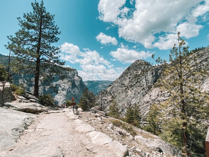
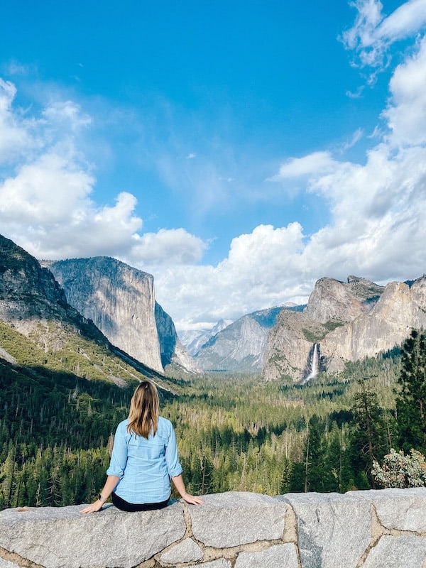
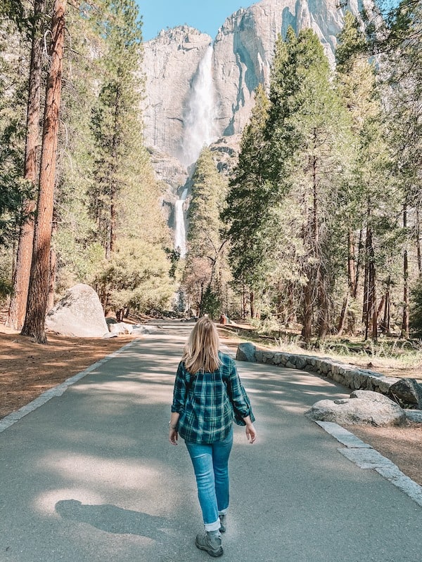
You never forget entering Yosemite National Park for the first time. This spectacular National Park located deep in the Sierra Nevada Mountains of California is one of the most beautiful National Parks in the United States.
There are five entrances to Yosemite National Park. Picking the best entrance to Yosemite depends on where you are coming from, road conditions, and where you are headed inside the Park.
I’ve visited Yosemite over a dozen times, and I’ve navigated Yosemite’s entrances in all conditions. In this guide, I’ll share more each entrance in more detail, the pros and cons of each entrance, as well as important driving and road condition information to help you choose the best entrance to Yosemite National Park. Let’s dive in!
Disclosure: This page may contain sponsored content or affiliate links, including Amazon links, where I earn a small commission from any purchase – at no extra cost to you. This commission helps keep Brooke In Boots up and running. As always, all opinions are 100% honest and my own!
IMPORTANT YOSEMITE UPDATE: Yosemite National Park now requires day-use and peak-hours reservations to enter Yosemite for dates in February & April – October. Learn more about these new changes, here.
The five entrances to Yosemite National Park are:
- Big Oak Flat Entrance or West Entrance (Highway 120 from Groveland)
- El Portal Entrance or Arch Rock Entrance or Central Entrance (Highway 140)
- Wawona or South Entrance (Highway 41)
- Tioga Road or East Entrance (Highway 120 from Lee Vining)
- Hetch Hetchy Entrance
So, which entrance is best?
In general, if you are headed to Yosemite Valley, the best entrance from San Francisco , north and west of Yosemite, is the Big Oak Flat Entrance.
The best entrance to Yosemite from Los Angeles, and south of Yosemite, is the Wawona Entrance.
And the best entrance from Reno, Tahoe and points east is the Tioga Road entrance.

Tips for Getting to Yosemite
Yosemite is huge—about the size of Rhode Island! The park sits in California’s Central Sierra Nevada Mountains, just north of Sequoia and Kings Canyon.
Most visitors drive to Yosemite, and having a car is highly recommended. If you’re staying outside the park, book lodging as close to an entrance as possible to cut down on drive time.
Here’s how far Yosemite Valley is from major cities:
- Merced – 2 hours
- Fresno – 2.5 hours
- Sacramento – 3.5 hours
- San Francisco / San Jose – 4.5 hours
- Los Angeles – 7 hours
Yosemite has multiple entrances, but some close in winter and one is daylight-only. Not sure which way to go? The good news is that all entrances (except Hetch Hetchy) lead to Yosemite Valley, the park’s main hub.
Take this itinerary to go! The printable Yosemite Itinerary Guide has your perfect 1, 2, or 3 day Yosemite trip completely planned for you! With over 20 pages of detailed hiking guides, printable daily itineraries, lodging and dining suggestions and more, you can spend less time planning and more time making epic memories! Check it out, here.
Map of the Entrances to Yosemite National Park
There are five vehicle entrances to Yosemite National Park. Which entrance you use will depend entirely on where you are coming from and where you are headed inside the Park.
To make matters more confusing, each entrance is referred to by several different names, even by NPS and Park staff.
The good news is that almost all roads (except Hetch Hetchy) eventually lead to Yosemite Valley, the hub of activity inside the Park. Use the map and directions below to plan your trip into Yosemite National Park.
Map of Yosemite National Park Entrances

Big Oak Flat Entrance or West Entrance (Highway 120 from Groveland)
The Big Oak Flat Entrance or West Entrance enters Yosemite National Park through Highway 120 from the town of Groveland, California.
When is this the best entrance to Yosemite? If you are driving from the Bay Area (San Francisco, Oakland,) or Sacramento, the Big Oak Flat Entrance is generally the best entrance to Yosemite National Park.
- Best Lodging near Big Oak Flat Entrance
- Maximum Vehicle Length: 45 Feet
- Height Restrictions: 10’3″ tunnels from the Valley, 13’8″ from center.
- Seasonal Restrictions: Open Year Round, weather permitting. Chains may be required during winter.

Driving to Yosemite via Big Oak Flat Entrance
Heading to Yosemite from the west? Take Highway 120 east. If you need supplies, Oakdale is your best bet for groceries before reaching the park.
Just before the entrance, you’ll tackle New Priest Grade Road, a steep, winding climb into the Sierra Foothills. It can feel intense, especially before sunrise, but it’s totally doable—just take it slow. Avoid Old Priest Grade Road—this shortcut is dangerously steep (up to a 20% grade!) and a nightmare for brakes, let alone RVs and trailers.
Once inside Yosemite, Big Oak Flat Road takes you down into Yosemite Valley through scenic tunnels (note: there’s a 10’3″ height restriction for vehicles coming from the Valley).
Using the Big Oak Flat Entrance in Winter
While this is the most direct route from the Bay Area, it’s not always the best winter option. The road climbs to higher elevations than Highway 140 (El Portal Entrance), meaning it’s more prone to ice and snow.
If you’re visiting in winter or early spring, consider Highway 140 instead. It follows the Merced River and stays at lower elevations, making for an easier and safer drive in snowy conditions.
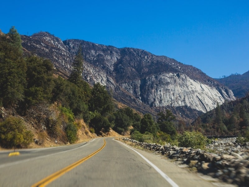
El Portal Entrance or Arch Rock Entrance or Central Entrance (Highway 140)
Driving to Yosemite via the El Portal Entrance
Also known as the Arch Rock Entrance, the El Portal Entrance follows Highway 140 into Yosemite, just past the town of El Portal.

This is the best entrance for visitors from San Jose since it’s the most direct route. Bay Area travelers may also prefer it, especially in winter, since Highway 140 stays at lower elevations and avoids the steep, icy climbs of other entrances.
Before reaching the park, you’ll pass through Mariposa (about an hour from Yosemite Valley). This small town has a grocery store, restaurants, and lodging—perfect if you need supplies or a place to stay outside the park.
Along the way, don’t miss the hidden waterfalls, Cascades and Wildcat falls, only visible along this stretch of Highway 140.
- Lodging near El Portal / Arch Rock Entrance
- Maximum Vehicle Length: 45 feet for single vehicle, 60 feet for combination vehicle, 35 feet for towed vehicle from hitch to rear bumper.
- Height Restrictions: 10’2″ from the curb in Wawona Tunnel.
- Seasonal Restrictions: Open Year Round, weather permitting. Chains may be required during winter.
Wawona or South Entrance (Highway 41)
Driving to Yosemite via the Wawona Entrance
Also known as the South Entrance, this route follows Highway 41 through Oakhurst and Fish Camp into Yosemite.
This is the best entrance for visitors coming from Fresno, Los Angeles, San Diego, and other points south. It’s also ideal if you’re staying at the Wawona Hotel, Redwoods in Yosemite cabins, Yosemite West rentals, or Wawona Campground.
From here, you’ll have easy access to Mariposa Grove, Glacier Point (seasonal), and Badger Pass Ski Area (seasonal).
- Lodging near Wawona Entrance
- Maximum Vehicle Length: 45 feet
- Height Restrictions: 13″
- Seasonal Restrictions: Open Year Round, weather permitting. Chains may be required during winter.
Entering Yosemite through Wawona Entrance
From Fresno, Highway 41 is a straightforward road into the Sierra foothills. The Highway gradually ascends into oak and scrub hills before climbing to over 6,000′ at the Wawona entrance.
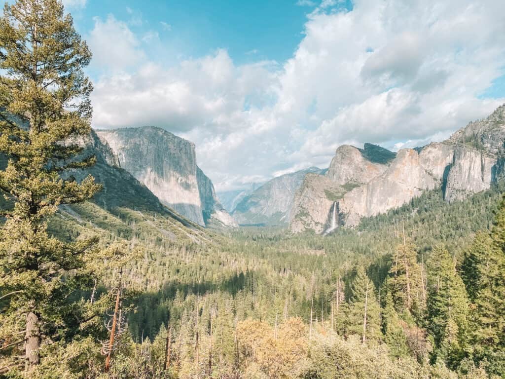
From Wawona, you will descend over 1 hour into Yosemite Valley before arriving at quite possibly the most famous view in any National Park: The Wawona Tunnel. Even if you aren’t entering or exiting through Highway 41 – make sure to check out the Wawona Tunnel as part of your epic Yosemite Itinerary!
If you are heading to the Park from the South and want that “wow I can’t believe my eyes” moment when entering Yosemite Valley, the Wawona / South Entrance is my pick for the best entrance to Yosemite National Park.
Growing up in Southern California, this is the entrance to Yosemite that I used most frequently. And let me tell you, even after dozens of visits, this road takes my breath away every time!
Tioga Road or East Entrance (Highway 120 from Lee Vining)
There is only one entrance to Yosemite from the eastern side of the Sierra Range. The eastern entrance is Tioga Road (or East Entrance), a continuation of Highway 120 through the Park and into the town of Lee Vining on the rugged eastern Sierras.
When is this the best entrance to Yosemite? If you are driving to Yosemite from Reno, Lake Tahoe, Mammoth Lakes, Death Valley, Highway 395 or all points east of the Park, the best entrance is the Tioga Road or East Entrance to Yosemite National Park.
- Lodging near Tioga Road / East Entrance
- Maximum Vehicle Length: None. Learn more about driving a trailer on Tioga Road, here.
- Height Restrictions: None
- Seasonal Restrictions: Tioga Road is closed seasonally in the winter, usually from late-November to May (or later in high-snow years).
Entering Yosemite via Tioga Road
From Lee Vining, it’s a steep, 20-minute drive to the Tioga Pass entrance at nearly 10,000 feet. Along the way, you’ll pass Tuolumne Meadows, Tenaya Lake, and Olmsted Point, with plenty of world-class hiking trails.
If Tioga Road is open during your visit, don’t miss this scenic drive!
It takes about 2 hours to reach Yosemite Valley from the East Entrance. There are no trailer or height restrictions, but steep grades (up to 8%) require careful driving, especially for those towing.
If you are visiting Yosemite while Tioga Road is open, you absolutely should stop here! This entrance to Yosemite is one of the most scenic drives in any National Park. Learn more about visiting Tioga Road and Tuolumne Meadows and plan your ultimate Yosemite National Park Itinerary here.
Seasonal Closures
Tioga Road is the only entrance that fully closes in winter due to heavy snow and avalanche risk. It typically shuts down late October to mid-November and reopens in May, depending on snowpack levels. On April 1, the snowpack is measured against the historic average of 222 inches (18.5 feet!).
In high snow years, Tioga road may not open until much later. In the historic winter of 2023, Tioga Road could not be cleared until almost August!
Recent Tioga Road Closing and Opening Dates
| Year | Opening Date (Spring) | Closing Date (Winter) | Snowpack % |
|---|---|---|---|
| 2023 | July 22 | TBD | 244% |
| 2022 | May 27 | October 31 | 41% |
| 2021 | May 27 | October 21 | 63% |
| 2019 *2020 Excluded due to COVID delays | July 1 | November 19 | 176% |
| 2018 | May 21 | November 20 | 67% |
Waiting for Tioga to reopen? Check the Tioga Road plow status, here, when snow removal begins every April.
Hetch Hetchy Entrance

If you are interested in visiting the Hetch Hetchy Reservoir area of Yosemite National Park, you will need to enter using the Hetch Hetchy Entrance. The Hetch Hetchy Entrance is located on Hetch Hetchy Road, off Highway 120 / Big Oak Flat Road. The turnoff for Hetch Hetchy is a short distance from the Highway 120 / Big Oak Flat entrance to Yosemite.
The Hetch Hetchy entrance is unique in that it is the only entrance that does not lead to Yosemite Valley. It is also the only entrance that is not open 24 hours a day.
When is this the best entrance to Yosemite? The Hetch Hetchy reservoir is only accessible from this entrance. You cannot get to Yosemite Valley, or any other areas of Yosemite from this entrance.
- Maximum Vehicle Length: 25 feet
- Height Restrictions: 8 feet (mirror to mirror); RVs take note: most RVs shorter than 25 feet are more than 8 feet wide and are NOT permitted on Hetch Hetchy Road.
- Seasonal Restrictions: Hetch Hetchy road is open year-round, but may close due to ice and snow or be subject to chain restrictions.
Hetch Hetchy Entrance Hours
The Hetch Hetchy entrance is only open during daylight hours. There is no vehicle access to the Hetch Hetchy area when the road is closed.
The Hetch Hetchy Entrance is open during the following hours:
April 1 to April 30: 8 am to 7 pm
May 1 to Labor Day: 7 am to 9 pm
Day after Labor Day to October 31: 8 am to 7 pm
November 1 to March 31: 8 am to 5 pm
What is Hetch Hetchy?
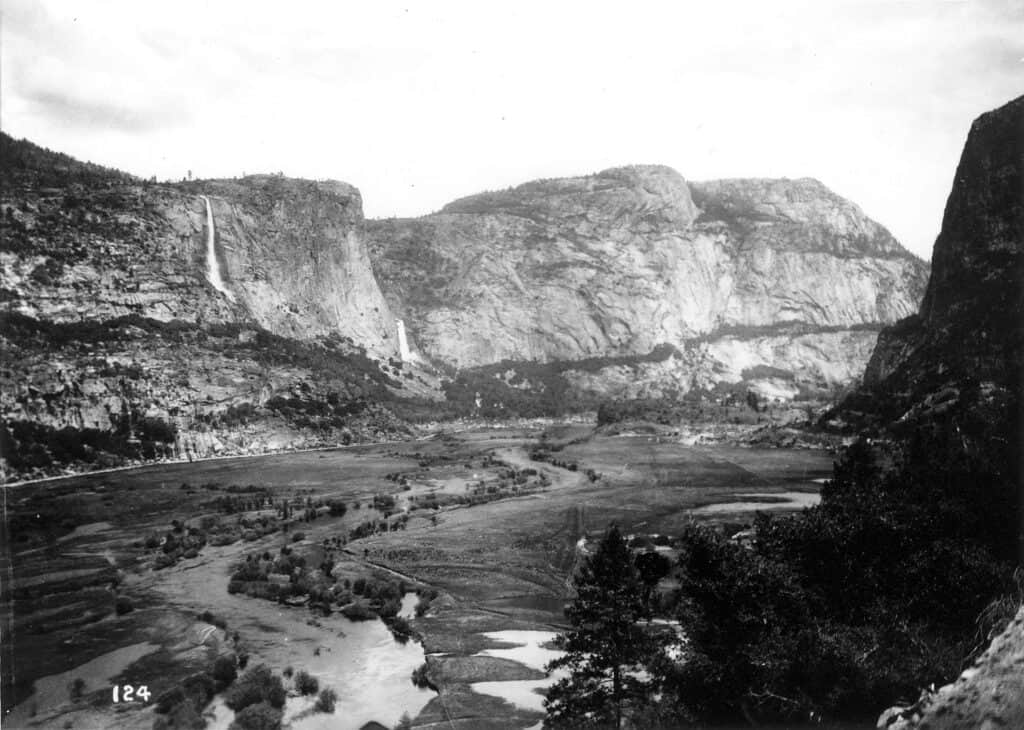
Did you know there is a valley in Yosemite, filled with some of the tallest waterfalls in North America and soaring granite cliffs? No I’m not talking about Yosemite Valley, its Hetch Hetchy Valley.
Before 1923, Hetch Hetchy Valley was said to rival Yosemite Valley for its magnificent beauty. But in the early 1900s, as the population of San Francisco and the Bay Area exploded, the city, state and US governments went looking for a stable water supply. To supply water, the Tuolumne River would be dammed and the Hetch Hetchy Valley turned into a massive reservoir.
After much controversy, in 1923, the O’Shaughnessy Dam was completed and the valley filled with water. To this day, the Bay Area continues to draw from the Hetch Hetchy reservoir, and the Valley submerged under hundreds of feet of water.
Dam Hetch Hetchy! As well dam for water-tanks the people’s cathedrals and churches, for no holier temple has ever been consecrated by the heart of man.
John Muir, Naturalist
The federal government, state of California, and city of San Francisco all still opposed the decommissioning of the damn. Groups like Restore Hetch Hetchy continue to work to bring back and preserve this magnificent piece of wilderness for the benefit and enjoyment of all people.
Getting from Yosemite Valley to Hetch Hetchy
Hetch Hetchy is located 38 miles from Yosemite Valley. It takes about 1 Hour and 15 minutes to drive from the Valley to Hetch Hetchy. There is no public transportation to Hetchy Hetchy, so you’ll need to bring your own vehicle.
To travel between Yosemite Valley (and other areas inside Yosemite) and Hetch Hetchy, you will need to exit the Park via the Big Oak Flat Entrance (Highway 120). On Big Oak Flat Road, turn right on Evergreen Road. In the (very) small town of Mather, turn right onto Hetch Hetchy Road, and follow to the entrance station.
Take this itinerary to go! The printable Yosemite Itinerary Guide has your perfect 1, 2, or 3 day Yosemite trip completely planned for you! With over 20 pages of detailed hiking guides, printable daily itineraries, lodging and dining suggestions and more, you can spend less time planning and more time making epic memories! Check it out, here.
Tips for Driving to Yosemite National Park
IMPORTANT YOSEMITE UPDATE: Yosemite National Park now requires day-use and peak-hours reservations to enter Yosemite for dates in February & April – October. Learn more about these new changes, here.
Tips for Driving to Yosemite
Driving to Yosemite is straightforward and stunning, but expect winding mountain roads and steep drop-offs as you ascend into the Sierra.
Roads are well-maintained but busy, and wildlife frequently cross the highways in and around Yosemite, so follow posted speed limits and traffic signs.
Don’t rely on cell service—it’s spotty or nonexistent in most of the park.
Download or print your itinerary before you go. Also, double-check your directions! Yosemite is huge, with multiple entrances, and just typing “Yosemite” into your GPS won’t take you to the right spot.
During peak season (late spring to early fall), be prepared for long entrance lines and packed parking lots. A little patience and kindness go a long way toward a smoother Yosemite adventure!
Taking Public Transportation to Yosemite National Park
Unlike many National Parks, public transportation IS AVAILABLE to Yosemite Valley. Daily bus service is provided by Yosemite Area Rapid Transit (YARTS) year-round.
YARTS operates 4 routes to Yosemite Valley and gateway communities and hotels. The routes depart from Merced (including the Merced Regional Airport, Geyhound, and Amtrak Station), Fresno (including Fresno-Yosemite Airport and Amtrak/Greyhound Station), Mammoth Lakes / Highway 395, and Senora.
Reservations are strongly recommended for YARTS buses. However, visitors arriving via YARTS do NOT need an additional peak-hours or day-use reservation to enter the park (when required).
Only the Merced / Highway 140 Route operates year-round, and services are reduced during winter and holidays. Learn more about the YARTS bus and make reservations, here.
Want to learn more about planning an epic National Parks trip? Grab my free Ultimate National Parks Planning Guide, including 70+ pages of National Park packing checklists, planning tips, and everything you need to know to start planning a trip to all 63 National Parks!
Driving & Parking In Yosemite National Park
Parking in Yosemite Valley
Getting around Yosemite Valley is easy thanks to the excellent Shuttle system. Once you arrive in Yosemite National Park, park your vehicle at your hotel or campground if you are staying overnight.
Guests of the hotels and campgrounds will be provided with a dashboard pass to park at these locations. Makes sure to display your parking pass at all times! If you do not have a pass, do not park at these locations.
If you are staying outside the Valley, park in one of the designated day-use parking lots. Use the map below to find Day-Use Parking in the Valley. Most visitors will want to park at the Visitor Center and Village Parking. The excellent Yosemite Valley Shuttle will pick you up there and take you to all major sights in the Valley – for free! Learn more about using the Yosemite Valley Shuttle, below.
Parking Lots fill to capacity early during late Spring to early Fall, especially on weekends and holidays. Plan to arrive well before 9AM for day-use parking lots.
Bear Safety and Your Vehicle in Yosemite National Park: Yosemite is home to hundreds of black bears. While most visitors never see a bear, it is important (and legally required) to take proper precautions, especially when it comes to food storage.
During the Day, store your food out of sight inside your vehicle, with the windows rolled up. At night, DO NOT leave any food or scented items in your vehicle. Bring them into your hotel or use a bear-proof food storage locker. Lockers are available at every campsite, Curry Village, and Housekeeping.
Remember, “food” means any scented items, including lotions, sunscreen, trash, and empty coolers.
Violating these rules can get you a hefty fine, your vehicle impounded, or your car totally destroyed by a curious bear. Bears who routinely break into vehicles or begin associating humans with tasty food have to be euthanized. By safely storing your food, you are protecting yourself AND the lives of these beautiful animals.
Driving to Glacier Point
Glacier Point is quite simply one of the most stunning views in Yosemite, and a must on any Yosemite itinerary (weather permitting). Parking is available along Glacier Point Road and at Glacier Point.
It takes approximately 1 hour to drive from Yosemite Valley to Glacier Point.
There is no free shuttle between Yosemite Valley and Glacier Point. However, the Glacier Point guided bus tour is a 4 hour guided tour from the Valley Floor, up 3,200 feet to stunning Glacier Point. Purchase a round trip ticket for $57, or a one-way ticket for $28 and hike down to the Valley via the Four Mile Trail (STRENUOUS), or vice-versa.
Shuttles and Tour Buses Inside Yosemite National Park
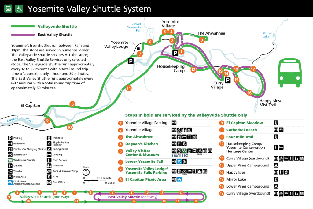
Yosemite Valley Shuttle
The Yosemite Valley Shuttle is one of the most convenient and easy-to-use shuttles in the entire National Park system. Its also free. Park your car at your lodging, campground or day-use parking lot and walk to the nearest shuttle stop (never far in the Valley).
Two shuttle lines run in Yosemite Valley: the East Valley Shuttle; and the Valleywide Shuttle. Shuttles are free to use, run between 7am and 10pm, and arrive every 8 to 22 minutes.
Most major sights and trailheads within Yosemite Valley are within a short walk of a shuttle stop.
Glacier Point Guided Bus Tour
There is no free shuttle between Yosemite Valley and Glacier Point. However, the Glacier Point guided bus tour is a 4 hour guided tour from the Valley Floor, up 3,200 feet to stunning Glacier Point.
Purchase a round trip ticket for $57, or a one-way ticket for $28 and hike down to the Valley via the Four Mile Trail (STRENUOUS), or vice-versa.
Tuolumne Meadows Shuttle and Hiker Bus
Parking along the Tioga Road corridor is limited and often frustrating. The Tuolumne Meadows Shuttle ($) provides service between Tuolumne Meadows Lodge and Olmstead Point, from mid-June to mid-September. Park your car at the Lodge and take the shuttle to various trails and sights along Tioga Road.
Learn more about the Tuolumne Meadows Shuttle, here.
If you want to avoid driving the 3+ hours round trip drive between Yosemite Valley and Tuolumne Meadows, consider booking a seat on the Hiker Bus. The Hiker Bus offers shuttle service between Yosemite Valley and various trailheads along Tioga Road. Learn more about the Hiker Shuttle, here.
Mariposa Grove Shuttle
Yosemite’s Mariposa Grove of Giant Sequoias, is home to over 500 Giant Sequoia trees. These massive trees are the largest living organisms on earth. Walk amongst these silent giants through a network of newly renovated trails and boardwalks.
When Mariposa Grove Road is open (generally April – December, weather permitting) visitors are required to park at the Mariposa Grove Welcome Center. From the Welcome Center, visitors can take the free shuttle 2 miles to the Grove. When Shuttle Service is running, only visitors with disability placards may park directly at the Grove.
Learn more about the Mariposa Grove Shuttle and accessing the Grove of Giant Sequoias, here.
More Yosemite Resources to Plan Your Next Trip
17 Amazing Easy & Short Hikes in Yosemite National Park
13 Iconic Yosemite Waterfalls & Waterfall Hikes in Yosemite National Park
Where to Stay in Yosemite: Best Hotels & Lodging for Every Budget
Yosemite Reservations and Permits 2024: Everything You Need to Know
Best Entrance to Yosemite National Park & Tips for Driving to Yosemite
Hiking the Mist Trail to Vernal and Nevada Falls in Yosemite